
Thames Water now wants 17 reservoir construction entrances, not six, and 60 lorry movements an hour on the A415 at peak. The traffic peak moves to 2030.
Thames Water has published revised construction plans for the reservoir it wants to build south west of Abingdon, and the numbers have moved in one direction.
The company now proposes 17 construction access points into the site, up from the six it assessed at last year’s statutory consultation. It says overall construction traffic will be higher than it forecast and reported at that consultation. And it now expects the peak of construction traffic across the whole project in 2030, not 2036 as previously forecast (Thames Water access point factsheet, September 2026).
The scheme is the South East Strategic Reservoir Option, which Thames Water has renamed White Horse Reservoir. The site sits west of the A34 between Marcham, Drayton, Steventon, East Hanney and Grove. The company plans to submit its Development Consent Order application to the Planning Inspectorate in November 2026 (Reservoir Newsletter, September 2026).
The main access is on the A415, and it takes 60 per cent of the traffic
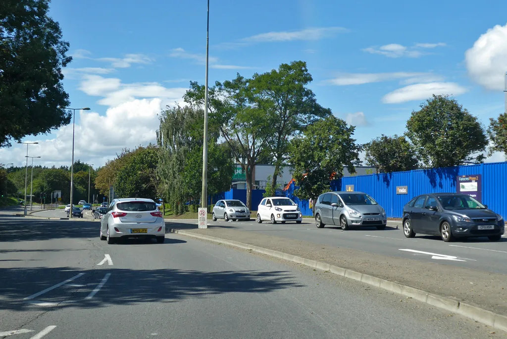
Access A1 is the one Abingdon drivers will notice. Thames Water routes it “via A415 Marcham Road”, and it would be the permanent entrance once the reservoir opens.
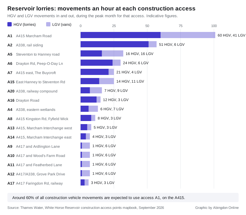
The company’s own mapbook gives the peak-month figure for that junction:
- 60 HGV movements an hour
- 41 LGV movements an hour
That is 101 goods vehicle movements in and out in an hour, roughly one every 36 seconds, in the busiest month at that access. Thames Water says around 60 per cent of all construction vehicle movements are currently expected to use A1 (Construction access points mapbook).
The second busiest is A2, off the A338 near East Hanney and Grove, at 51 HGV and 6 LGV movements an hour in its peak month. That access serves the temporary rail siding.
Where the 17 entrances would be
The factsheet gives an indicative route for each access. Twelve of them were identified after the statutory consultation, and 16 of the 17 would be temporary. Road names are as Thames Water published them.
| Access | Route in | Peak hour, HGV and LGV | Purpose |
|---|---|---|---|
| A1 | A415 Marcham Road | 60 and 41 | Main compound, becomes the permanent access |
| A2 | A338 | 51 and 6 | Rail siding, materials handling, Steventon to East Hanney road |
| A4 | A338 | 6 and 7 | Eastern wetlands |
| A5 | Steventon to Hanney road | 16 and 16 | East end of the road realignment |
| A6 | Drayton Road, Stonehill Lane, Peep-O-Day Lane | 24 and 6 | Intake and outfall structure on the Thames |
| A7 | A415 (East) and The Buycroft | 21 and 4 | Berm on the east bank of the Thames |
| A8 | A415 Kingston Road, Fyfield Wick, Hanney Road | 8 and 3 | Habitat creation, species relocation |
| A9 | A417 and Ardlington Lane | 1 and 6 | Habitat creation, species relocation |
| A10 | A417 and Wood’s Farm Road | 1 and 6 | Habitat creation, species relocation |
| A11 | A417 and Featherbed Lane | 1 and 6 | Habitat creation, species relocation |
| A12 | A417/A338 and Grove Park Drive | 1 and 6 | Habitat creation, species relocation |
| A13 | A415 Marcham Road and the road to Dalton Barracks | 5 and 3 | Compound for A34 Marcham Interchange works, west |
| A14 | A415 Marcham Road | 4 and 3 | Compound for A34 Marcham Interchange works, east |
| A15 | East Hanney to Steventon Road | 14 and 11 | Trial embankment, ecology, archaeology, demolition |
| A16 | Drayton Road | 12 and 3 | Intermediate shaft for the river tunnel |
| A17 | A417 Faringdon Road and Network Rail land | 3 and 3 | Compound for works to the railway |
| A20 | A338 and Network Rail land | 7 and 9 | Compound for works to the railway |
Two accesses in the earlier work have gone. A3 has been combined with A2. A18 and A19 “are no longer proposed and would not be used during construction”.
Why the traffic forecast went up
Thames Water gives the reason plainly. It has added light goods vehicles, used by suppliers, subcontractors and specialist trades, into its modelling for the first time. It also has a clearer picture of when and where construction activity would happen.
The company says it is engaging with local highway authorities and National Highways on mitigation. Final forecasts will appear in the Environmental Statement submitted with the DCO application.
It also expects rail to take some of the load. A temporary rail siding and materials handling facility at the southern end of the site, linked to the Great Western Main Line, could cut total HGV journeys during construction by around 31 per cent compared with moving everything by road.
The council already said Marcham Interchange cannot take it
This matters because Vale of White Horse District Council put its objections in writing in January, when the traffic numbers were lower.
In its statutory consultation response, the council told Thames Water that at peak construction the A34 Marcham Interchange would see modelled queues backing onto the A34 itself. It put the figure at over 100 vehicles queuing on the nearside lane south of the interchange slip lane, with 75 per cent of HGV traffic, in the scenario that already assumes rail is used.
The council said the effect should be reclassified as a Major, significant construction effect. It also said it was “surprised” that improvement works at Marcham Interchange were missing from the scheme’s draft commitments register.
Thames Water’s new access list does now include two compounds, A13 and A14, set up specifically for “A34 Marcham Interchange works”. The factsheet does not say what those works would be.
The council made two other points worth holding on to:
- in a hypothetical month with everything moved by road, it calculated 110 HGVs an hour, or 1,100 a day, of which about 31 an hour would pass through local settlements and junctions already shown to be over capacity
- it wants HGV scheduling written into the construction traffic plan so lorries avoid the morning and evening peaks
The timetable, including work before consent
The published sequence is not one long build. It comes in three overlapping phases, and the first one starts before any decision is made:
- 2027: early works could begin, creating and enhancing ecological habitats, “before development consent for the project is granted”
- November 2026: DCO application submitted to the Planning Inspectorate
- enabling works: building the new East Hanney to Steventon road, site clearance, demolitions, compounds, utility and watercourse diversions
- 2029: main construction forecast to begin, if consent is granted
- from 2032: the main construction phase, likely to take around 10 years
- 2040: the reservoir planned to begin operating
What it means for you
The consultation now running is not open to everyone. Thames Water is carrying out targeted consultation with landowners, occupiers and nearby parties whose land could be affected by the access points.
It is also explicit about what is off the table. The factsheet says the consultation “is not a consultation on the need for the project, the location of the reservoir, predicted traffic numbers or other changes to the project proposals since statutory consultation”.
So if you live on one of the routes above and want the traffic numbers themselves tested, the moment to act is the DCO examination, not now. When the Planning Inspectorate accepts the application, it opens a registration period. Anyone who wants their views formally considered must register and submit a Relevant Representation, which makes them an Interested Party with the right to take part. The examination itself runs for six months, the Examining Authority then has three months to write its recommendation, and the Secretary of State has three more to decide.
General queries go to whitehorsereservoir@thameswater.co.uk. The Vale’s own position, and its consultation responses, are on the council’s reservoir page. The council does not make the final decision, but it will prepare a Local Impact Report for the examination.
For what is already affecting local journeys, see our Abingdon roadworks and travel page, and for other applications in the district, Abingdon planning news.
What else has changed
- the proposal to relocate three solar farms to land west of the reservoir has been dropped, after feedback on location, grid connection availability and environmental risk. Floating solar on the reservoir itself stays in the plan
- Thames Water reports more than 2,500 responses to the statutory consultation, which ran from 28 October 2025 to 13 January 2026, and over 1,200 people at nine consultation events
- survey work so far: over 7,500 environmental surveys, 1,500 archaeological trial trenches, and 10 observational trial pits, of which more than half are dug
- mitigation being considered includes fixed HGV routes, avoiding unsuitable local roads, keeping lorries away from schools, and noise and air quality monitoring, to be set out in a Code of Construction Practice published with the application
Sources
- Thames Water, Developing our plans for access points for the proposed construction of White Horse Reservoir, September 2026, for the 17 access points, the routes, the phases, the 31 per cent rail figure and the scope of the targeted consultation
- Thames Water, Construction access points mapbook, September 2026, for the peak-month hourly HGV and LGV movements at each access
- Thames Water, Reservoir Newsletter, September 2026, for the November 2026 DCO date, the solar farm decision, the response totals and the survey counts
- Vale of White Horse District Council, SESRO statutory consultation response, January 2026, for the Marcham Interchange queuing, the 110 HGVs an hour figure and the commitments register point
- Thames Water, White Horse Reservoir project page
Have your say